Herman Moll began work on “The World Described or, A New and Correct Sett of Maps” in 1707 and continued to work until it was completed in 1717. Originally published as a folio edition, this series took into account all of the known parts of the globe.
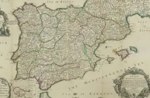
This map, Plate XXVI, is titled “SPAIN Divided intos its severall KINGDOMS and PRINCIPALITIES according as they are comprehended under the CROWNS of CASTILE and ARAGON, In the Possession of his CATHOLICK MAJESTY, And under the CROWN of PORTUGAL in the possession of the KING of PORTUGAL.”
It is described in the Atlas’s Index as:
SPAIN and PORTUGAL, divided into its Kingdoms and Principalities, describing the principal Roads &c. with the Placed mark’d where Battles have been fought by the English, and the Dates of the Years.


")
")