• Login
  • Register
  • FAQ
  • Contact Us
  • Home
  • Documents
  • Activities
  • Activity Tools
    • All Tools
    • Analyzing Documents
    • Discussion Topic
    • Compare and Contrast
    • Zoom/Crop
    • White Out / Black Out
    • Spotlight
    • Finding a Sequence
    • Making Connections
    • Mapping History
    • Seeing the Big Picture
    • Weighing the Evidence
    • Interpreting Data
  • Popular Topics
    • See All
    • National History Day
    • The Constitution
    • Sports: All-American
    • Rights in America
    • American Indians
    • Women's Rights
    • American Revolution
    • The Civil War
    • World War I
    • World War II
    • The Vietnam War
    • 1970s America
    • Congress
    • Amending America
    • Elections
    • What Americans Eat
    • Signatures
    • Nixon and Ford Years
  • Resources
    • Getting Started
    • Document Analysis
    • Activity-Creation Guide
    • Manage Assignments
    • iPad App
    • Presentation Materials
    • Webinars
      • Recorded Webinars
      • Live Webinars
MENU
DocsTeachThe online tool for teaching with documents, from the National Archives National Archives Foundation National Archives

Map Showing the Distribution of the Slave Population of the Southern States of the United States

1861

Print
Add to Favorites:
Add
Saving document...
Your document has been saved.
Add all page(s) of this document to activity:
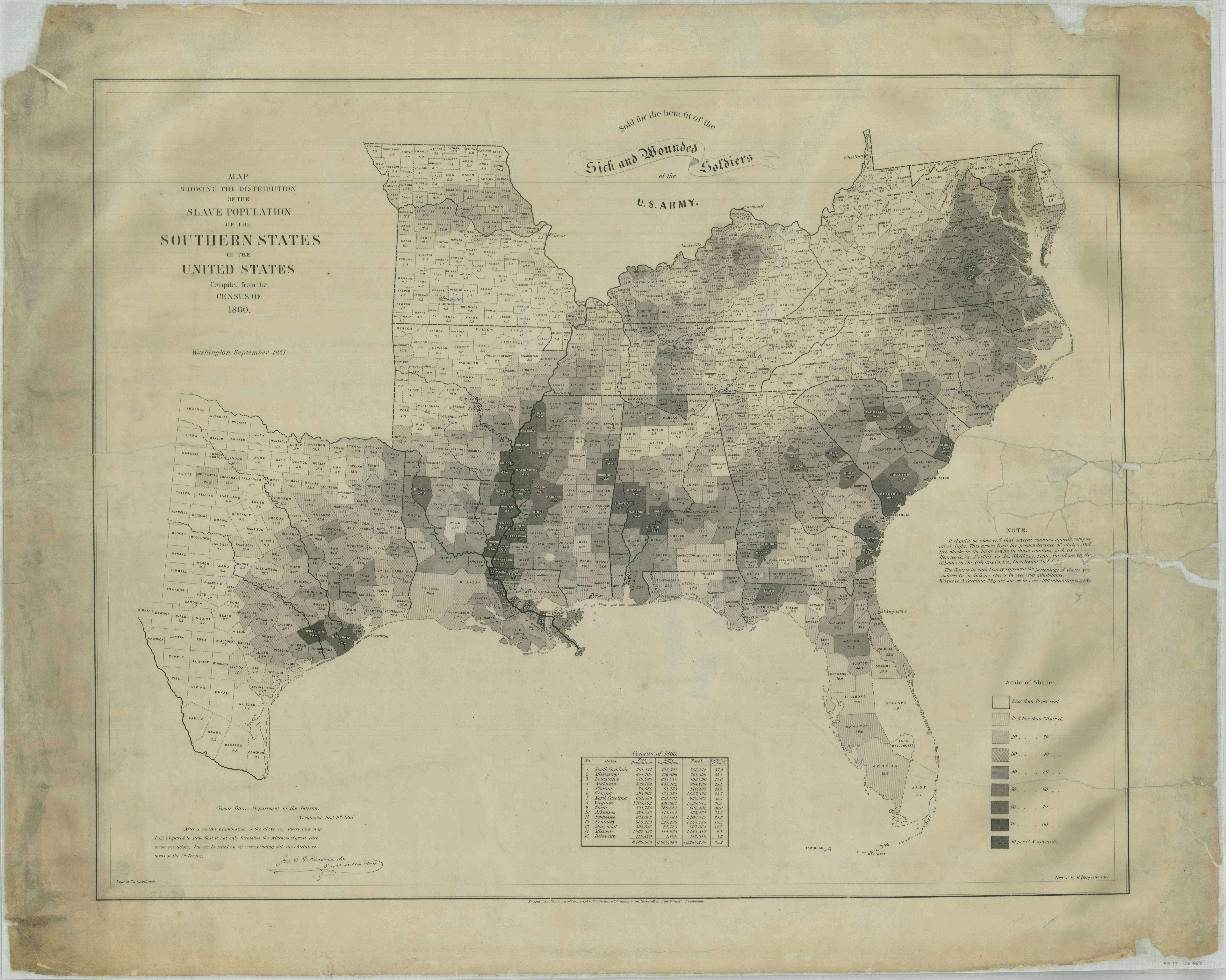
This map represents one of the first American attempts to translate census data into a visual representation on a map. It was created in 1861 by the U.S. Coastal Survey using statistical data from the 1860 census.

The map shows the percentage of enslaved people by county, with different colors reflecting the percentage. It provides a visual picture of how enslaved persons were distributed across the Southern States.

It was reported to have been a favorite map for President Abraham Lincoln to consult during the Civil War, and is depicted in Francis Bicknell Carpenter’s famous painting “First Reading of the Emancipation Proclamation of President Lincoln.”
This primary source comes from the Records of the Office of the Chief of Engineers.
National Archives Identifier: 86455714
Full Citation: Map Showing the Distribution of the Slave Population of the Southern States of the United States; 1861; United States; Civil Works Map File, 1818 - 1947; Records of the Office of the Chief of Engineers, Record Group 77; National Archives at College Park, College Park, MD. [Online Version, https://docsteach.org/documents/document/map-slave-population-of-southern-states, March 29, 2023]
Return to ResultsReturn

Activities that use this document

  • 1860 Slavery Map of the United States
    Created by the National Archives Education Team

Rights: Public Domain, Free of Known Copyright Restrictions. Learn more on our privacy and legal page.

  • Explore Primary Source Documents
  •  
  • Discover Activities You Can Teach With
  •  
  • Create Fun & Engaging Activities
Follow us on Twitter:twitter
Follow us on Facebook:facebook
Please enter a valid email address

View our webinars:youtube

Get our iPad app:apple
New Documentsshare
New Activitiesshare

The National Archives

DocsTeach is a product of the National Archives education division. Our mission is to engage, educate, and inspire all learners to discover and explore the records of the American people preserved by the National Archives.

The National Archives and Records Administration is the nation's record keeper. We save documents and other materials created in the course of business conducted by the U.S. Federal government that are judged to have continuing value. We hold in trust for the public the Declaration of Independence, the Constitution, and the Bill of Rights — but also the records of ordinary citizens — at our locations around the country.
  • All Education Programs
  • Student Visits
  • Distance Learning
  • Professional Development
  • National Archives Museum
  • Presidential Libraries
  • Archives.gov
  • National Archives Foundation


Creative Commons License

Except where otherwise noted, DocsTeach is licensed under a Creative Commons Attribution-NonCommercial-ShareAlike 4.0 International License. Primary source documents included on this site generally come from the holdings of the National Archives and are in the public domain, except as noted. Teaching activities on this site have received the CC0 Public Domain Dedication; authors have waived all copyright and related rights to the extent possible under the law. See our legal and privacy page for full terms and conditions.