Aerial Photograph of the Golden Gate Bridge
1953
Add to Favorites:
Add all page(s) of this document to activity:

Additional details from our exhibits and publications
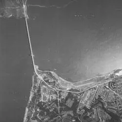
This 1953 aerial photograph shows the Golden Gate Bridge, linking San Francisco and Marin County, California. When this photograph was taken, the bridge had been open for 16 years, and at 4,200 feet, had a longer main suspension span than any other bridge in the world.
This primary source comes from the Records of the Farm Service Agency.
National Archives Identifier: 596318
Full Citation: Aerial Photograph of the Golden Gate Bridge; 1953; Records of the Farm Service Agency. [Online Version, https://docsteach.org/documents/document/aerial-photograph-of-the-golden-gate-bridge, May 30, 2023]Rights: Public Domain, Free of Known Copyright Restrictions. Learn more on our privacy and legal page.