Herman Moll began work on “The World Described or, A New and Correct Sett of Maps” in 1707 and continued to work until it was completed in 1717. Originally published as a folio edition, this series took into account all of the known parts of the globe.
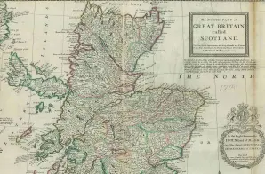
This map, Plate XVIII, is described in the Atlas’s Index as:
The NORTH Part of Great-Britain, called SCOTLAND, with considerable Improvements, and many Remarks not yet extant in any other Map; also, the views of Edinburg, Glasgow, St. Andrews, Sterling, Montross, and several other Places.


