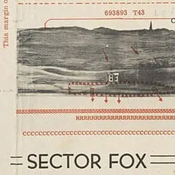
This map of Omaha Beach’s Dog and Fox sectors was drawn from the perspective of the assaulting troops to help them recognize their landing areas and locate enemy positions. The mapmaker used information from low-level reconnaissance flights, agent reports, and special operations troops who visited the beaches prior to the assault to ensure the map’s accuracy.
Panoramic Sketch of the D-Day Beaches
- 5/14/1944
Share to Google Classroom

View the full document here: https://docsteach.org/document/panoramic-dday-beaches/
Description
Citation
This primary source comes from the Records of Allied Operational and Occupation Headquarters, World War II, 1907 - 1966 .
National Archives Identifier: 595492
Full Citation: RG331-G2PAN-DDAY; Panoramic Sketch of the D-Day Beaches; 5/14/1944; Geographic Intelligence Maps, ca. 1944 – 1945; Records of Allied Operational and Occupation Headquarters, World War II, 1907 – 1966 , Record Group 331; National Archives at College Park, College Park, MD. [Online Version, https://docsteach.org/document/panoramic-dday-beaches/, April 5, 2026]
Rights: Public Domain, Free of Known Copyright Restrictions. Learn more on our privacy and legal page.
Related Documents
Japanese Internee Card for Fred Toyosaburo Korematsu
The Great Depression and World War II (1929-1945)
Postman Delivering Mail on a Rural Mail Route
The Great Depression and World War II (1929-1945)