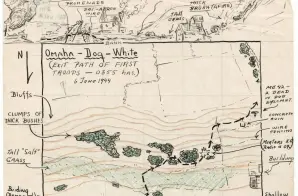
From the moment Allied forces disembarked from their landing craft on D-Day, they struggled with every step to achieve their objective under a constant hail of bullets. This sketch of the exit path for the first troops from the 29th Infantry to land at the Dog White sector of Omaha Beach illustrates many of the obstacles soldiers navigated as they pushed inland—including ocean tides, seawalls, long stretches without cover, mines, concertina wire, fences and bluffs.
Exit Path Map for Omaha Beach
- 6/6/1944
Share to Google Classroom

View the full document here: https://docsteach.org/document/omaha-dog-white/
Description
Citation
This primary source comes from the Records of the Adjutant General's Office, .
National Archives Identifier: 6922052
Full Citation: Omaha-Dog-White, Exit Path of First Troops, 0855 Hrs.; 6/6/1944; C. I. – 81 29th Inf Div. Omaha Beach (FD IV) June 6 THRU 10, 1944; World War II Operations Reports, 1940 – 1948; Records of the Adjutant General’s Office, , Record Group 407; National Archives at College Park, College Park, MD. [Online Version, https://docsteach.org/document/omaha-dog-white/, March 31, 2026]
Rights: Public Domain, Free of Known Copyright Restrictions. Learn more on our privacy and legal page.
Related Documents
Japanese Internee Card for Fred Toyosaburo Korematsu
The Great Depression and World War II (1929-1945)
Postman Delivering Mail on a Rural Mail Route
The Great Depression and World War II (1929-1945)