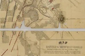
This map shows topography, rivers, vegetation, town, roads, railroads, troop positions, and residents during the Battle of Murfreesboro (also known as the Second Battle of Murfreesboro or the Battle of Stones River). The map describes that the battle was “fought from December 30, 1862, to January 3, 1863, between the Confederate forces under Gen. Bragg and the Federal forces under Maj. Gen. Rosencrans.”
It is one of several maps created by the Confederate States of America that were acquired by the U.S. War Department by capture or surrender during the Civil War, or by donation or purchase after the War. A note on the reverse says it was found at Macon, Georgia, on July 20, 1865.


