View the full document here: https://docsteach.org/document/map-showing-path-of-1938-hurricane/
Description
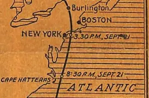
Original Caption: Where Tropical Hurricane Struck Along Atlantic Coast. Map showing cities and towns which have reported damage from floods and wind. The inset shows the path of the hurricane.
Citation
This primary source comes from the Records of the National Oceanic and Atmospheric Administration.
Full Citation: Map Showing Path of 1938 Hurricane; ca. 1938; [General Photographs and Exhibit Material]; Photographs, 1880 – 1974; Records of the National Oceanic and Atmospheric Administration, Record Group 370; National Archives at Boston, Waltham, MA. [Online Version, https://docsteach.org/document/map-showing-path-of-1938-hurricane/, April 4, 2026]