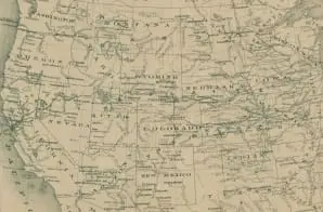
This map depicts the location of various U.S. Army posts, American Indian reservations, and principal routes of the states and territories within the Military Division of the Missouri, which was first established in 1865.
The Military Division of the Missouri varied in size throughout its history, but in 1872, when the map was created, it generally included the states Illinois, Iowa, Kansas, Minnesota, Missouri, Nebraska, and Texas; and the territories Colorado, Montana, New Mexico, Utah, Wyoming, Indian Territory, and the Dakota Territory.
In addition, the nation’s first Transcontinental Railroad passed through the Military Division of the Missouri as it connected the Atlantic coast to the Pacific coast by rail.


