
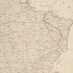
Map of the Boundary of Eastern France
- 1918
Share to Google Classroom
View the full document here: https://docsteach.org/document/map-of-the-boundary-of-eastern-france/
Description
This French map of Eastern France illustrates the often-disputed boundary between France and Germany. The map is part of the records of the American Expeditionary Forces (AEF). The AEF was created in 1917 to conduct military operations against Germany during World War I.
Citation
This primary source comes from the Records of the American Expeditionary Forces (World War I).
National Archives Identifier: 596202
Full Citation: Map of the Boundary of Eastern France; 1918; Strategic Operation Maps, 1918–1919; Records of the American Expeditionary Forces (World War I), Record Group 120; National Archives at College Park, College Park, MD. [Online Version, https://docsteach.org/document/map-of-the-boundary-of-eastern-france/, April 10, 2026]
Rights: Public Domain, Free of Known Copyright Restrictions. Learn more on our privacy and legal page.
Related Documents

Flag bearers in the Independence Day Parade, New York City
The Emergence of Modern America (1890-1930)

July 4th Parade passing the New York Public Library
The Emergence of Modern America (1890-1930)

Girls carrying a large American flag in the Independence Day Parade, New York City
The Emergence of Modern America (1890-1930)