
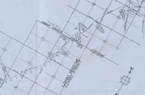
Map of Missouri, Kansas, and Oklahoma Railroad, Section of 13.55 miles in Oklahoma Territory
- 8/14/1902
Share to Google Classroom
View the full document here: https://docsteach.org/document/map-missouri-kansas-oklahoma-railroad-13-miles/
Citation
This primary source comes from the Records of the Bureau of Indian Affairs.
National Archives Identifier: 260950936
Full Citation: CMF 2517; Map of Missouri, Kansas, and Oklahoma Railroad, Section of 13.55 miles in Oklahoma Territory; 8/14/1902; Central Map File, 1824 – 1960; Records of the Bureau of Indian Affairs, Record Group 75; National Archives at College Park, College Park, MD. [Online Version, https://docsteach.org/document/map-missouri-kansas-oklahoma-railroad-13-miles/, March 27, 2026]
Rights: Public Domain, Free of Known Copyright Restrictions. Learn more on our privacy and legal page.
Related Documents

To America under the American Flag
The Emergence of Modern America (1890-1930)

Aviators at Camp Dick, Texas, are taking certain calisthenics
The Emergence of Modern America (1890-1930)
