
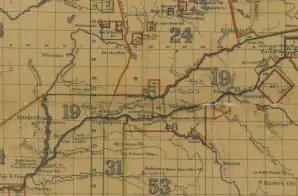
Map of the State of Indiana Exhibiting the Lands Ceded by the Indian Tribes to the United States
- 1881
Share to Google Classroom
View the full document here: https://docsteach.org/document/map-indiana-lands-ceded-by-indian-tribes/
Citation
This primary source comes from the Records of the Bureau of Indian Affairs.
National Archives Identifier: 25464547
Full Citation: Map of the State of Indiana Exhibiting the Lands Ceded by the Indian Tribes to the United States; 1881; Central Map File, 1824 – 1960; Records of the Bureau of Indian Affairs, Record Group 75; National Archives at College Park, College Park, MD. [Online Version, https://docsteach.org/document/map-indiana-lands-ceded-by-indian-tribes/, June 20, 2026]
Rights: Public Domain, Free of Known Copyright Restrictions. Learn more on our privacy and legal page.
Related Documents

Ku Klux Klan Act of 1871
Civil War and Reconstruction (1850-1877)

Correspondence Relating to the Employment of Sarah Ann Degan
Civil War and Reconstruction (1850-1877)
