
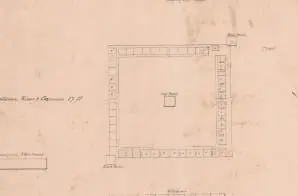
Map of Fort Gibson, Cherokee Nation [Oklahoma]
- ca. 1834-1837
Share to Google Classroom
View the full document here: https://docsteach.org/document/map-fort-gibson-cherokee-nation-oklahoma/
Citation
This primary source comes from the Records of the Office of the Chief of Engineers.
National Archives Identifier: 241570208
Full Citation: Map of Fort Gibson, Cherokee Nation [Oklahoma]; ca. 1834-1837; Fort Gibson, Oklahoma; Plans of Military Posts in the United States, 1840 – 1947; Records of the Office of the Chief of Engineers, Record Group 77; National Archives at College Park, College Park, MD. [Online Version, https://docsteach.org/document/map-fort-gibson-cherokee-nation-oklahoma/, July 24, 2026]
Rights: Public Domain, Free of Known Copyright Restrictions. Learn more on our privacy and legal page.
Related Documents

Survey of St. John River and British Settlements of New Brunswick
Expansion and Reform (1801-1861)


Petition in Bankruptcy of Edgar Allen Poe
Expansion and Reform (1801-1861)