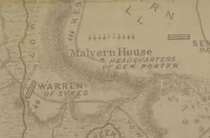
This map shows topography, rivers, vegetation, roads, troop positions, and some residents. It is one of several maps created by the Confederate States of America that were acquired by the U.S. War Department by capture or surrender during the Civil War, or by donation or purchase after the War.
A note on the back of the map reads: “Savannah Georgia, December 27, 189[illegible], This map must have come into my possession during the war, for I have made no collection of papers relating to the war, since it terminated. But I cannot remember at this date, from whom it came, nor the time it was received. The words “Map of Malvern Hill” are in my handwriting. McLaws.” Maj. Gen. Lafayette McLaws was a Confederate general whose division fought in the Battle of Malvern Hill.


