Herman Moll began work on “The World Described or, A New and Correct Sett of Maps” in 1707 and continued to work until it was completed in 1717. Originally published as a folio edition, this series took into account all of the known parts of the globe.
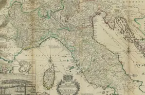
This map of Italy with engravings showing fortifications around several cities, listed as Plate XXVIII in the Atlas index, is described as:
The Upper Part of Italy; containing the Principality of Piedmont, the Dutchies of Savoy, Milan, Parma, Mantua, Modena, Tuscany; the Dominions of the Pope, the Republics of Venice, Genoa, Lucca, &c. Dedicated to his Majesty King George II. This Map is ornamented with a Prospect of Leghorn. The Plains of the Fortifications of Rome, Florenza, Parma, Placenza, Genoa, Turin, Milan, Cevitta Vecchia, & c.


")
")