
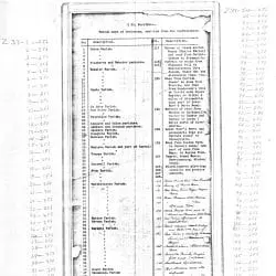
Index to Captured Confederate Parish Maps of Louisiana
- 1865
Share to Google Classroom
View the full document here: https://docsteach.org/document/index-to-captured-confederate-parish-maps-of-louisiana/
Citation
This primary source comes from the Records of the Office of the Chief of Engineers.
National Archives Identifier: 5900024
Full Citation: Index to Captured Confederate Parish Maps of Louisiana; 1865 ; Records of the Office of the Chief of Engineers, Record Group 77. [Online Version, https://docsteach.org/document/index-to-captured-confederate-parish-maps-of-louisiana/, April 6, 2026]
Rights: Public Domain, Free of Known Copyright Restrictions. Learn more on our privacy and legal page.
Related Documents

Ku Klux Klan Act of 1871
Civil War and Reconstruction (1850-1877)

Correspondence Relating to the Employment of Sarah Ann Degan
Civil War and Reconstruction (1850-1877)
