Nearly two months before the invasion of France, this hydrographic chart of the Normandy coast indicates the beach sectors that were chosen for the pending amphibious assault.
Chart of D-Day Beaches
- 4/14/1944
Share to Google Classroom

View the full document here: https://docsteach.org/document/dday-beaches-chart/
Description
Citation
This primary source comes from the Records of Allied Operational and Occupation Headquarters, World War II.
National Archives Identifier: 595474
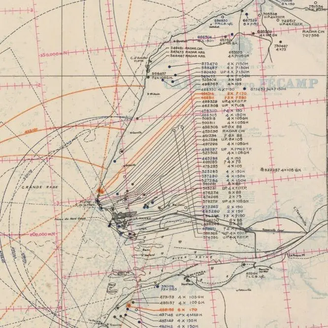
Full Citation: RG331-G3NEPTUNE; Chart of D-Day Beaches; 4/14/1944; Maps of Military Plans and Operations, June 1944–April 1945; Records of Allied Operational and Occupation Headquarters, World War II, Record Group 331; National Archives at College Park, College Park, MD. [Online Version, https://docsteach.org/document/dday-beaches-chart/, March 18, 2026]
Rights: Public Domain, Free of Known Copyright Restrictions. Learn more on our privacy and legal page.
Related Documents
Japanese Internee Card for Fred Toyosaburo Korematsu
The Great Depression and World War II (1929-1945)
Postman Delivering Mail on a Rural Mail Route
The Great Depression and World War II (1929-1945)