
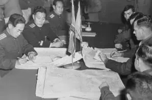
Colonel James Murray, Jr., USMC, and Colonel Chang Chun San, of the North Korean Communist Army, initial maps showing the north and south boundaries of the demarcation zone, during the Panmunjom cease
- 10/11/1951
Share to Google Classroom
View the full document here: https://docsteach.org/document/colonel-james-murray-jr-usmc-and-colonel-chang-chun-san-of-the-north-korean-communist-army-initial-maps-showing-the-north-and-south-boundaries-of-the-demarcation-zone-during-the-panmunjom-cease-fire-t/
Citation
This primary source comes from the General Records of the Department of the Navy.
National Archives Identifier: 520806
Full Citation: Colonel James Murray, Jr., USMC, and Colonel Chang Chun San, of the North Korean Communist Army, initial maps showing the north and south boundaries of the demarcation zone, during the Panmunjom cease; 10/11/1951; General Records of the Department of the Navy, Record Group 80. [Online Version, https://docsteach.org/document/colonel-james-murray-jr-usmc-and-colonel-chang-chun-san-of-the-north-korean-communist-army-initial-maps-showing-the-north-and-south-boundaries-of-the-demarcation-zone-during-the-panmunjom-cease-fire-t/, April 3, 2026]
Rights: Public Domain, Free of Known Copyright Restrictions. Learn more on our privacy and legal page.
Related Documents

Surrender of the Japanese at Seoul, Korea
Postwar United States (1945 to early 1970s)
 to all female HCIS personnel re")
Memo to All Female Staff of Internal Security Committee
Postwar United States (1945 to early 1970s)

Letter from Andrew S. Evans to President Harry S. Truman
Postwar United States (1945 to early 1970s)