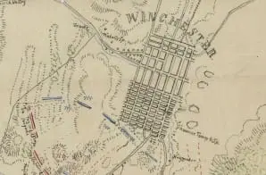
This map, drawn by by Jedediah Hotchkiss, shows topography, vegetation, rivers, roads, troop positions, towns, and residents during the First Battle of Winchester on May 25, 1862. The back reads “TJ Jackson’s report.” It is one of several maps created by the Confederate States of America that were acquired by the U.S. War Department by capture or surrender during the Civil War, or by donation or purchase after the War.


