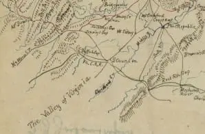
This map illustrates “the pursuit of the enemy” during Stonewall Jackson’s Valley Campaign. The red line shows the route of Jackson’s “Army of the Valley” through Shenandoah Valley, from Franklin in Pendleton County (now part of West Virginia) on May 15, 1862, to Winchester, through June 25, 1862. Drawn by Jedediah Hotchkiss, the map also shows topography, rivers, roads, railroads, and towns.
The back reads “TJ Jackson’s report.” It is one of several maps created by the Confederate States of America that were acquired by the U.S. War Department by capture or surrender during the Civil War, or by donation or purchase after the War.


