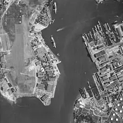
This aerial photograph shows the naval base at Pearl Harbor on Oahu, Hawaii (then the Territory of Hawaii), on January 17, 1941. The U.S. Navy was in the process of expanding Pearl Harbor to serve as home port for its Pacific Fleet when this photograph was taken. Just 11 months later on December 7, Japanese forces attacked here, driving the United States into World War II. Hard hit in the attack were the ships anchored along “Battleship Row” on Ford Island, which can be seen in the upper left portion of the photograph.
Aerial Photograph of Pearl Harbor, Hawaii
- 1/17/1941
Share to Google Classroom

View the full document here: https://docsteach.org/document/aerial-photograph-pearl-harbor/
Description
Citation
This primary source comes from the Records of the Defense Intelligence Agency.
National Archives Identifier: 595097
Full Citation: ON 002917, EX-M-32-30-18; Aerial Photograph of Pearl Harbor, Hawaii; 1/17/1941; Aerial Photographs, 1935–1970; Records of the Defense Intelligence Agency, Record Group 373; National Archives at College Park, College Park, MD. [Online Version, https://docsteach.org/document/aerial-photograph-pearl-harbor/, April 2, 2026]
Rights: Public Domain, Free of Known Copyright Restrictions. Learn more on our privacy and legal page.
Related Documents
Japanese Internee Card for Fred Toyosaburo Korematsu
The Great Depression and World War II (1929-1945)
Postman Delivering Mail on a Rural Mail Route
The Great Depression and World War II (1929-1945)