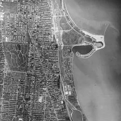
This aerial photograph from November 24, 1938, shows the North Side section of Chicago, Illinois. Located on the southwestern edge of Lake Michigan, the city suffered a disastrous fire in 1871, but then underwent a building boom which continued into the 20th century. In this photograph, Montrose Peninsula can be seen in the upper right quadrant, while Belmont Harbor can be seen further south.
Aerial Photograph of Chicago, Illinois
- 11/24/1938
Share to Google Classroom

View the full document here: https://docsteach.org/document/aerial-photograph-chicago-illinois/
Description
Citation
This primary source comes from the Records of the Farm Service Agency.
National Archives Identifier: 595106
Full Citation: Can IL 093, BWQ-7-71; Aerial Photograph of Chicago, Illinois; 11/24/1938; Aerial Photographs of the United States, 1934–1994; Records of the Farm Service Agency, Record Group 145; National Archives at College Park, College Park, MD. [Online Version, https://docsteach.org/document/aerial-photograph-chicago-illinois/, May 25, 2026]
Rights: Public Domain, Free of Known Copyright Restrictions. Learn more on our privacy and legal page.
Related Documents
Japanese Internee Card for Fred Toyosaburo Korematsu
The Great Depression and World War II (1929-1945)
Postman Delivering Mail on a Rural Mail Route
The Great Depression and World War II (1929-1945)