America's Growth West
Mapping History
All documents and text associated with this activity are printed below, followed by a worksheet for student responses.Introduction
After the end of the Revolutionary War, American began to expand to the massive area west of the Appalachian Mountains. The first half of the 19th century saw leaps in expansion, migration, and admittance of new states, allowing American to expand its borders and influence further than it had gone before. In this activity you will trace some of these event, mapping out how America was changed by westward expansion and settlement. Place the pictures on the state or region in which the event took place, thus showing how America's expansion west changed a nation.Name:
Class:
Class:
Worksheet
America's Growth West
Mapping History
Examine the documents and text included in this activity. Consider how each document or piece of text relates to the image shown below. Write the corresponding document or text number on the image where you think it belongs. (Some may be placed for you already.) Write your conclusion response in the space provided.
1
Activity Element

2
Activity Element
3
Activity Element
Oregon Trail Reenactment
Page 1
4
Activity Element
Memorial of the inhabitants of Nauvoo in Illinois, praying redress for injuries to the persons and property by lawless proceedings of citizens of Missouri (Joseph Smith, et al)
Page 1

5
Activity Element
Message of President Millard Fillmore nominating territorial officers of Utah, including Brigham Young to be Governor
Page 1

6
Activity Element
Map of Nebraska and Kansas Territories, showing the location of the Indian Reserves according to the treaties of 1854
Page 2

7
Activity Element
Message of President John Tyler transmitting to Congress a letter from John Chambers, Governor of Iowa, accompanied by a memorial from the legislative assembly of Iowa asking to be admitted as a state
Page 1
8
Activity Element
Letter of the Delegate of the Territory of Utah in Congress enclosing the Memorial of Delegates of the Convention which assembled in Great Salt Lake City and adopted a constitution with a view to the
Page 1

9
Activity Element
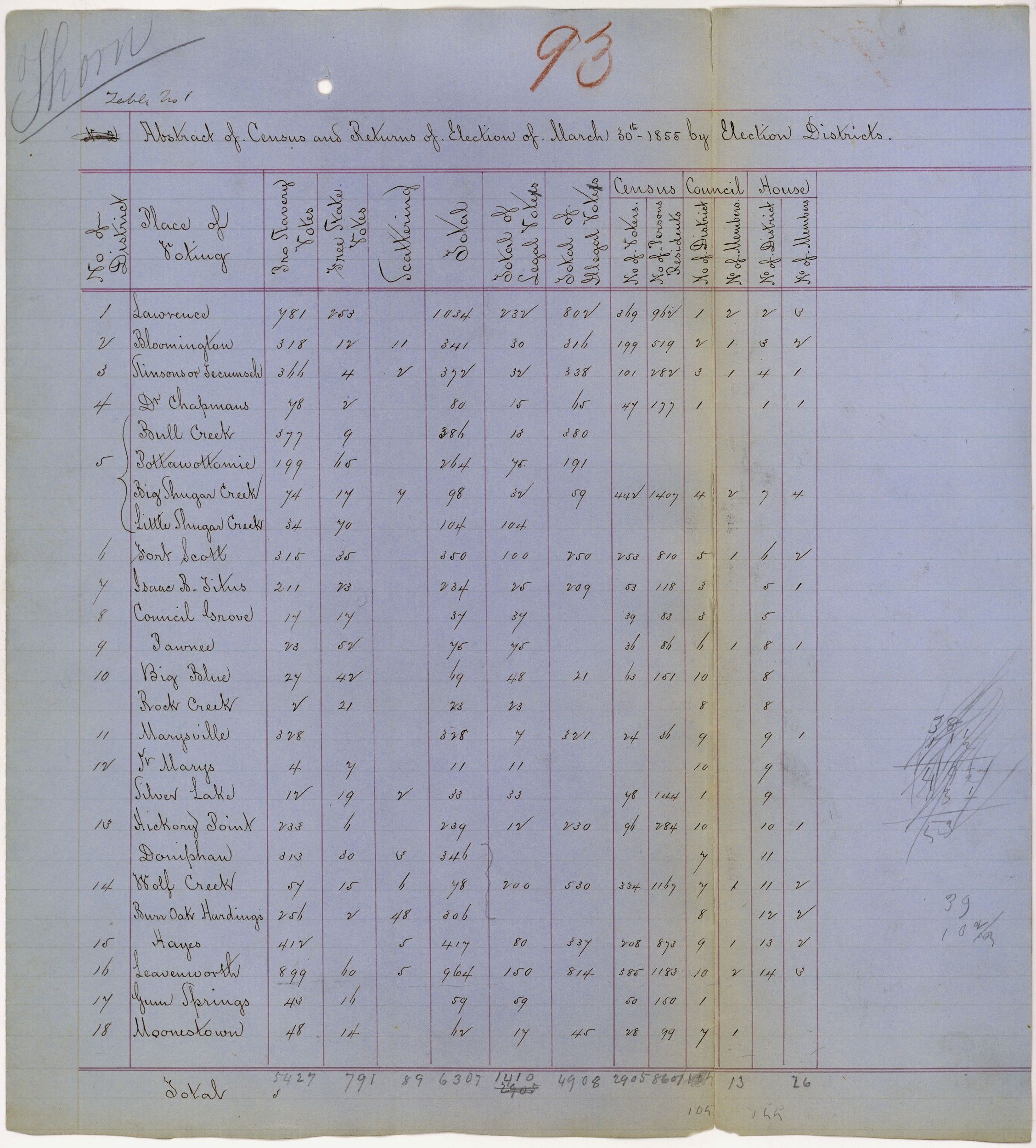
Abstract of census and returns of election of a territorial legislature in Kansas
Page 1
10
Activity Element
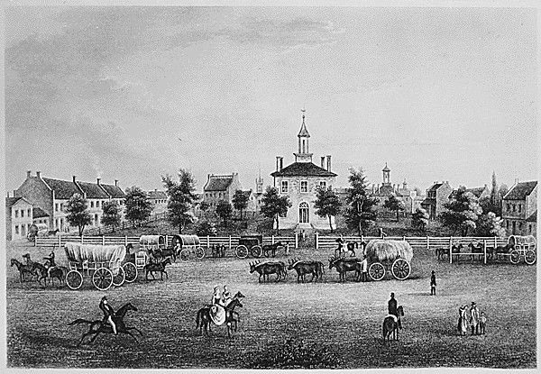
"lndependence-Courthouse-Missouri."
Page 1
11
Activity Element
Photograph of a Family with Their Covered Wagon During the Great Western Migration
Page 1

12
Activity Element
Map of the Louisiana Purchase Territory
Page 1

13
Activity Element
Message of President James K. Polk to the Senate Concerning the Defense of American Citizens in the Oregon Territory
Page 1

14
Activity Element
Letter from the Scholars of Mandeville College to President James K. Polk Regarding Oregon
Page 1

15
Activity Element
Constitution of the State of Texas
Page 1
16
Activity Element
Sketch Map (Diseno) of California Land Claim
Page 1
17
Activity Element
Poster Advertising "Indian Territory That Garden of the World, Open for Homestead and Pre-Emption" in Current Day Oklahoma
Page 2
Conclusion
America's Growth West
Mapping History
After you have completed placing the pictures on the map pick three events which you feel had the greatest impact on the United States as a nation. After choosing these events explain why you chose them and explain their impact on the nation or the region.Your Response
Document
'lndependence-Courthouse-Missouri.'
1855
Engraving from The United States Illustrated by Charles A. Dana (New York 1855).
This primary source comes from the Records of the Bureau of Public Roads.
National Archives Identifier: 513335
Full Citation: 'lndependence-Courthouse-Missouri.'; 1855; Records of the Bureau of Public Roads, . [Online Version, https://docsteach.org/documents/document/lndependencecourthousemissouri, May 4, 2024]'lndependence-Courthouse-Missouri.'
Page 1

Document
Abstract of census and returns of election of a territorial legislature in Kansas
3/30/1855
This primary source comes from the Records of the U.S. House of Representatives.
National Archives Identifier: 306580
Full Citation: Abstract of census and returns of election of a territorial legislature in Kansas; 3/30/1855; Records of the U.S. House of Representatives, . [Online Version, https://docsteach.org/documents/document/abstract-of-census-and-returns-of-election-of-a-territorial-legislature-in-kansas, May 4, 2024]Abstract of census and returns of election of a territorial legislature in Kansas
Page 1

Document
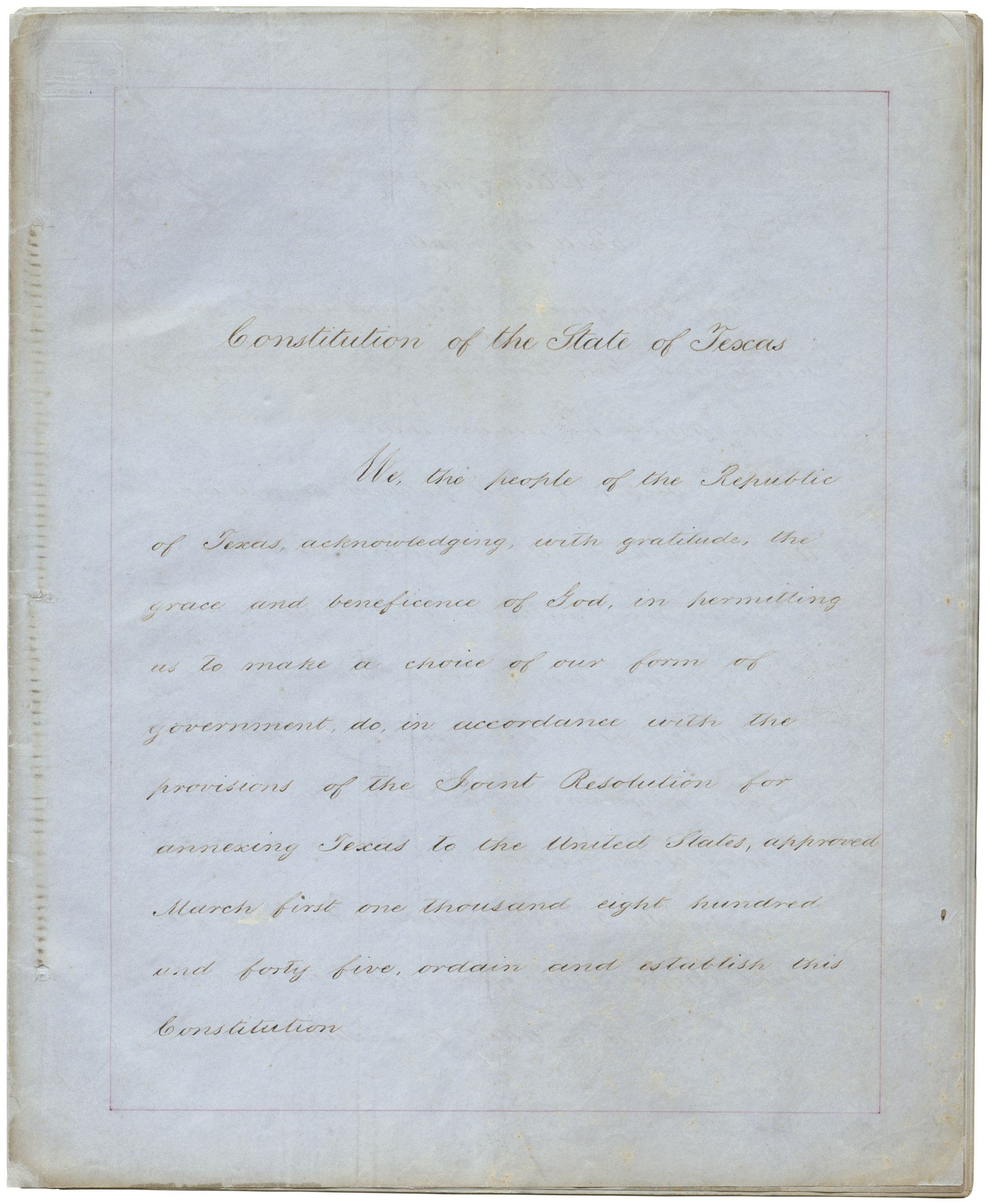
Constitution of the State of Texas
11/10/1845
Additional details from our exhibits and publications
This is the first constitution of the state of Texas. Ratified by Texas citizens and the U.S. Congress in 1845, it was modified in 1861 to transfer allegiance to the Confederacy. After the Civil War, Texas was required to write a new constitution before it could be readmitted to the United States.
This primary source comes from the Records of the U.S. Senate.
National Archives Identifier: 595453
Full Citation: Constitution of the State of Texas; 11/10/1845; Records of the U.S. Senate, . [Online Version, https://docsteach.org/documents/document/constitution-of-the-state-of-texas, May 4, 2024]Constitution of the State of Texas
Page 1

Constitution of the State of Texas
Page 2

Document
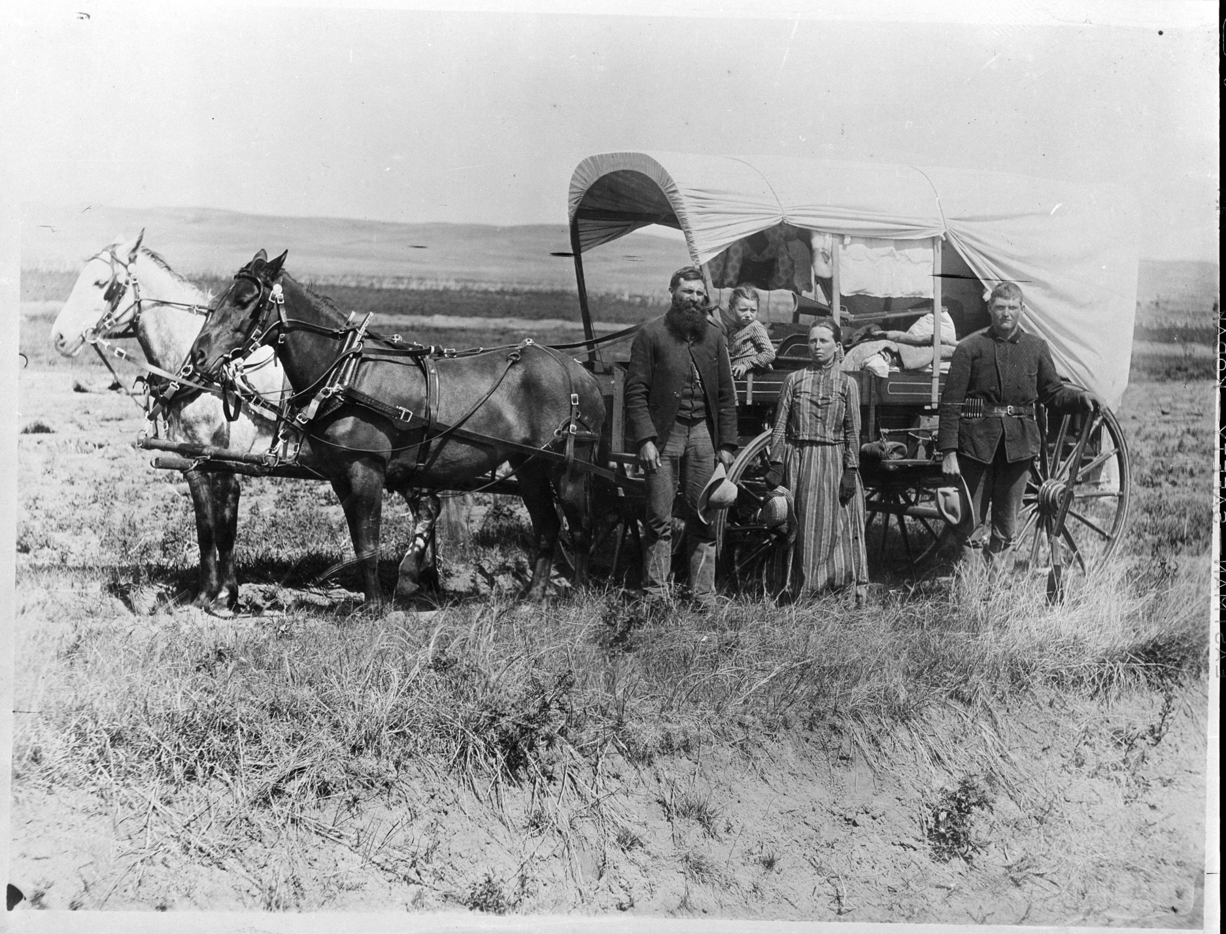
Family with Their Covered Wagon During the Great Western Migration
1866
The original caption for this photograph reads: "The Covered Wagon of the Great Western Migration. 1886 in Loup Valley, Nebr." A family poses with the wagon in which they live and travel daily during their pursuit of a homestead.
The image shows a family pausing to pose for a picture in Loup Valley, Nebraska, on their journey to a homestead. The Homestead Act of 1862 allowed a citizen to claim up to 160 acres of western lands in exchange for farming and improving that land.
Text adapted from “The Homestead Act of 1862” in the October 1997 National Council for the Social Studies (NCSS) publication Social Education, which includes background information and teaching suggestions about The Homestead Act.
This primary source comes from the Records of the Work Projects Administration.
National Archives Identifier: 518267
Full Citation: Photograph 69-N-13606C; Family with Their Covered Wagon During the Great Western Migration; 1866; WPA Information Division Photographic Index, ca. 1936 - ca. 1942; Records of the Work Projects Administration, ; National Archives at College Park, College Park, MD. [Online Version, https://docsteach.org/documents/document/family-covered-wagon, May 4, 2024]Family with Their Covered Wagon During the Great Western Migration
Page 1
Document
Letter from the Scholars of Mandeville College to President James K. Polk Regarding Oregon
1844
This item consists of a letter from the "Scholars of Mandeville College" to President Polk encouraging him not to relinquish "one inch" of Oregon to Great Britain.
Additional details from our exhibits and publications
In this letter, “fifty odd scholars” of Mandeville College in Louisiana advised President James K. Polk not to relinquish an inch of Oregon. They not only echoed his 1844 campaign slogan of “Fifty-four Forty or Fight,” they also offered their 50 bodies and 50 muskets to affirm the American claim.
This primary source comes from the General Records of the Department of State.
National Archives Identifier: 595435
Full Citation: Letter from the Scholars of Mandeville College to President James K. Polk Regarding Oregon; 1844; General Records of the Department of State, . [Online Version, https://docsteach.org/documents/document/letter-from-the-scholars-of-mandeville-college-to-president-james-k-polk-regarding-oregon, May 4, 2024]Letter from the Scholars of Mandeville College to President James K. Polk Regarding Oregon
Page 1

Document
Letter of the Delegate of the Territory of Utah in Congress enclosing the Memorial of Delegates of the Convention which assembled in Great Salt Lake City and adopted a constitution with a view to the
4/20/1858
This primary source comes from the Records of the U.S. Senate.
National Archives Identifier: 306508
Full Citation: Letter of the Delegate of the Territory of Utah in Congress enclosing the Memorial of Delegates of the Convention which assembled in Great Salt Lake City and adopted a constitution with a view to the ; 4/20/1858; Records of the U.S. Senate, . [Online Version, https://docsteach.org/documents/document/letter-of-the-delegate-of-the-territory-of-utah-in-congress-enclosing-the-memorial-of-delegates-of-the-convention-which-assembled-in-great-salt-lake-city-and-adopted-a-constitution-with-a-view-to-the-, May 4, 2024]Letter of the Delegate of the Territory of Utah in Congress enclosing the Memorial of Delegates of the Convention which assembled in Great Salt Lake City and adopted a constitution with a view to the
Page 1

Document
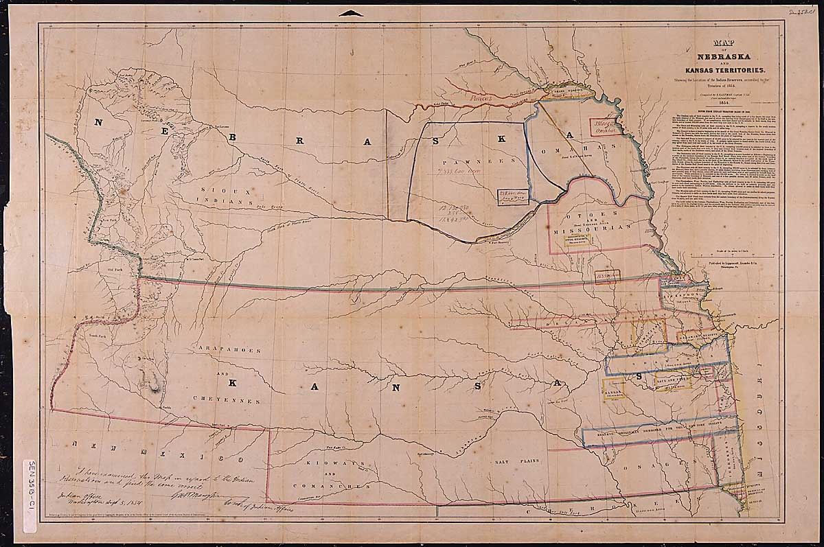
Map of Nebraska and Kansas Territories, showing the location of the Indian Reserves according to the treaties of 1854
1854
This map shows the location of the "Indian Reserves" according to the treaties of 1854.
This primary source comes from the Records of the U.S. Senate.
National Archives Identifier: 306436
Full Citation: Map of Nebraska and Kansas Territories, showing the location of the Indian Reserves according to the treaties of 1854; 1854; Presidential Messages to the Senate in the 35th Congress Transmitting Treaties and Other Papers Pertaining to Relations with the Pawnee Indians; Records Relating to Treaties with Indian Tribes, 1789 - 1871; Records of the U.S. Senate, ; National Archives Building, Washington, DC. [Online Version, https://docsteach.org/documents/document/map-nebraska-kansas, May 4, 2024]Map of Nebraska and Kansas Territories, showing the location of the Indian Reserves according to the treaties of 1854
Page 2
Document
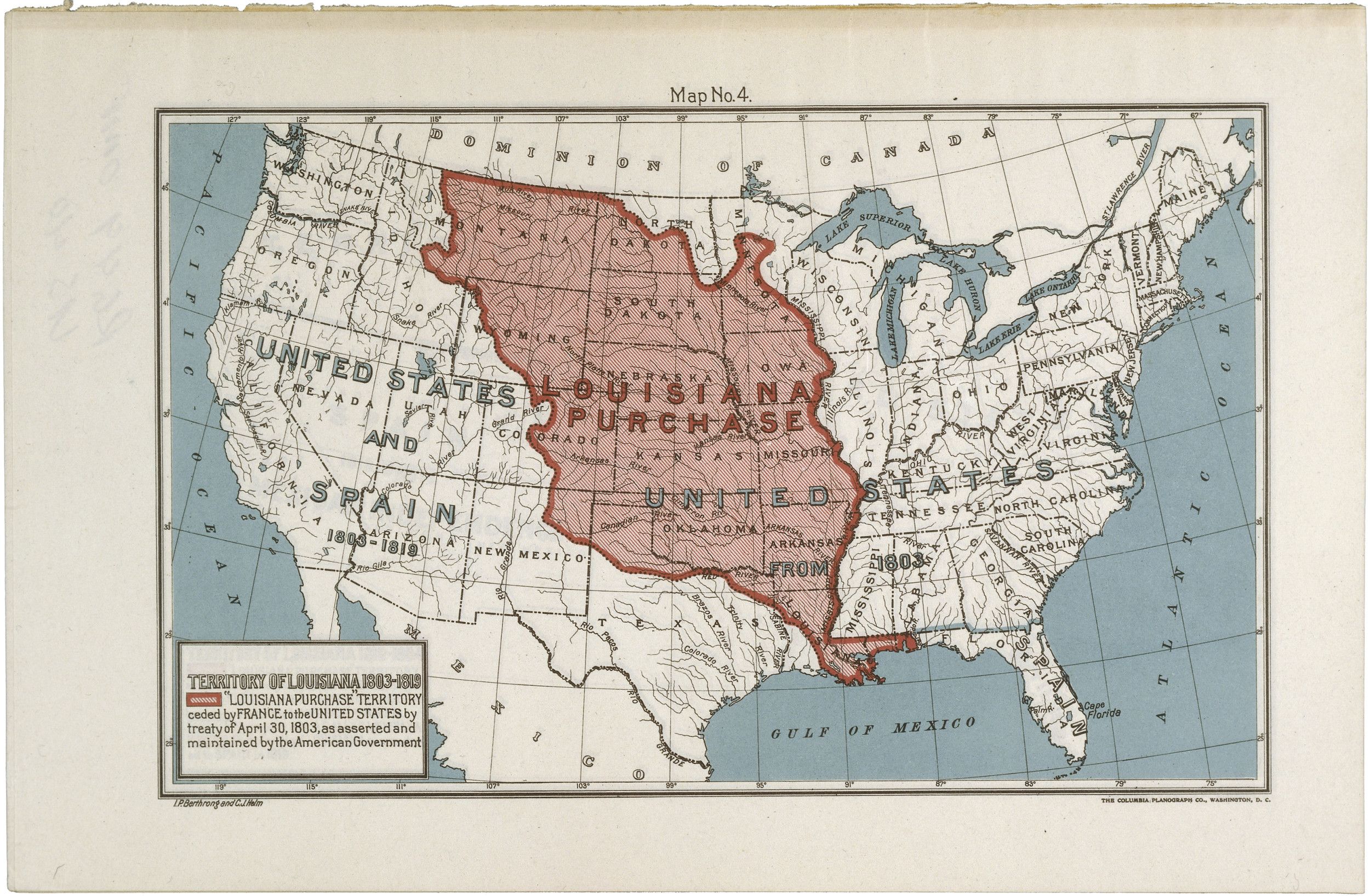
Map of the Louisiana Purchase Territory
1903
This map of the United States highlights in red the territory included in the Louisiana Purchase. Bought from France in 1803, the 820,000 square miles would eventually be split among the 16 states whose borders are outlined in black. The map was created for the centennial of the Louisiana Purchase in 1903.
This primary source comes from the Records of the Bureau of Land Management.
National Archives Identifier: 594889
Full Citation: Map RG49-OMF-US40-4; Map of the Louisiana Purchase Territory; 1903; United States; Old Map File Manuscript and Annotated Maps of the United States and Its Territories, 1812 - 1946; Records of the Bureau of Land Management, ; National Archives at College Park, College Park, MD. [Online Version, https://docsteach.org/documents/document/map-louisiana-purchase, May 4, 2024]Map of the Louisiana Purchase Territory
Page 1
Document
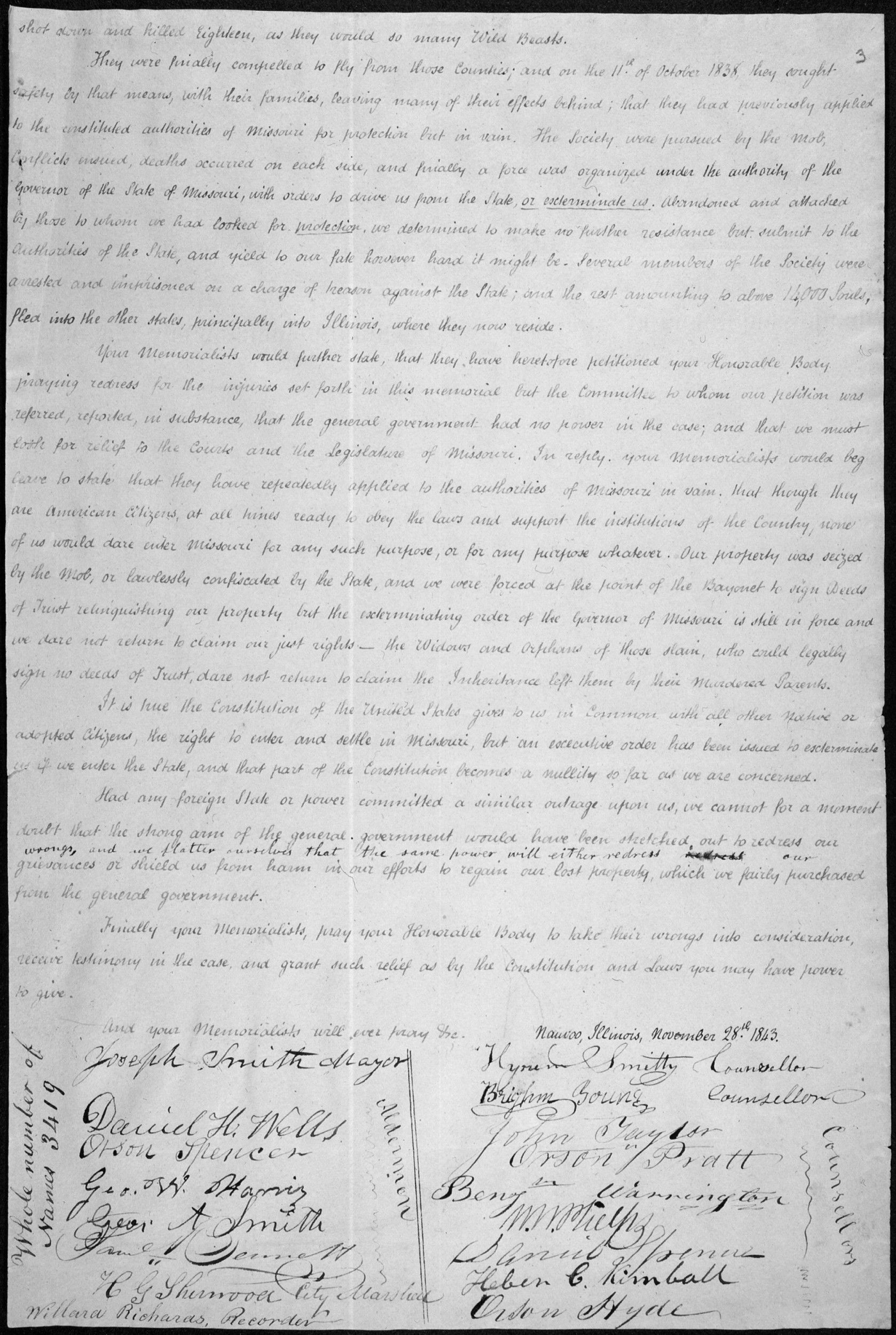
Memorial of Joseph Smith & Other Inhabitants of Nauvoo, Ill., Praying Redress for Injuries by Lawless Citizens of Missouri
11/28/1843
Mormon leader and Nauvoo, Illinois, Mayor Joseph Smith and other leaders, such as Brigham Young, sent this document to Congress recounting their experiences and treatment. They asked for redress for injuries to their persons and property by the "lawless proceedings of citizens of Missouri."
Transcript
To the Honorable the Senate and House of Representativesof the United States in Congress Assembled
The Memorial of the undersigned inhabitants of Hancock County in the State of Illinois respectfully sheweth:
That they belong to the Society of Latter Day Saints, commonly called Mormons, that a portion of our people commenced settling in Jackson County Missouri in the Summer of 1831, where they purchased lands and settled upon them with the intention and expectation of becoming permanent citizens in Common with others.
From a very early period after the Settlement began, a very unfriendly feeling was manifested by the neighboring people; and as the Society increased, this unfriendly Spirit also increased until it--- degenerated into a cruel and unrelenting persecution and the Society was at last compelled to leave the county. An account of these unprovoked persecutions has been published to the world, yet we deem it not improper to embody a few of the most prominent items in this memorial and lay them before your honorable body.
On the 20th of July 1833, a mob collected at Independence, a deputation or Committee from which, called upon a few members of our Church there, and stated to them that the Store, Printing Office, and all Mechanic Shops belonging to our people must be closed forthwith, and the Society leave the county immediately. These conditions were so unexpected and so hard, that a short time was asked for to consider on the subject before an answer could be given, which was refused, and when some of our men answered that they could not consent to comply with such propositions, the work of destruction--- commenced. The Printing Office, a valuable two story brick building was destroyed by the mob and with it much valuable property; they next went to the Store for the same purpose, but one of the owners thereof, agreeing to close it, they abandoned their design. A series of outrages was then commenced by the mob upon individual numbers of our Society; Bishop Partridge was dragged from his house and family where he was first partially stripped of his clothes and then tarred and feathered from head to foot. A man by the name of Allan was also tarred at the same time. Three days afterwards the Mob assembled in great numbers, bearing a red flag, and proclaiming that, unless the Society would leave “en masse” [underlined], every man of them should be killed. Being in a defenceless situation, to avoid a general massacre, a treaty was entered into and ratified, by which it was agreed that one half of the Society should leave the county by the first of January, and the remainder by the first of April following. In October, while our people were gathering their crops and otherwise preparing to fulfill their part of the treaty, the mob again collected without any provocation, shot at some of our people, whipped others, threw down their houses, and committed many other depredations; the members of the Society were for some time harassed, both day and night, their houses assailed and broken open, and their women and children insulted and abused. The Store house of A. S. Gilbert & Co. was broken open, ransacked, and some of the goods strewed in the streets. These repeated assaults so aroused the indignant feelings of our people that a small party thereof on one occasion, when wantonly abused, resisted the mob, a conflict ensued, in which one of our people
and some two or three of their assailants were killed. This unfortunate affair raised the whole County in arms, and we were required forthwith to surrender our arms and leave the County. Fifty one guns were given up, which have never been returned or paid for to this day. Parties of the mob from 30 to 70 in numbers then scoured the county in every direction, threatening and abusing women and children, until they were forced, first to take shelter in the woods and prairies at a very inclement season of the year, and finally to make their escape to Clay County, where the people permitted them to take refuge for a time.
After the Society had left Jackson County, their buildings amounting to about two hundred, were either burned or otherwise destroyed, with a great portion of their crops, as well as furniture, stock &c. for which they have not as yet received any remuneration. The Society remained in Clay County nearly three years, when in compliance with the demands of the citizens there, it was determined to remove to that section of county, known afterwards as Caldwell County. In order to secure our people from molestation, the members of the Society bought out most of the former Inhabitants of what is now Caldwell County, and also entered much of the wild land, then belonging to the United States in that Section of county, fondly hoping that as we were American Citizens, obeying the laws, and assisting to support the government, we would be protected in the use of homes which we had honestly purchased from the general government and fully paid for. Here we were permitted to enjoy peace for a season, but as our Society increased in numbers, and settlements were made in Davies and Carrol Counties, unfounded jealousies sprung up among our neighbors, and the spirit of the Mob was soon manifested again. The people of our Church who had located themselves at De Wit, were compelled by the Mob to leave the place, --- notwithstanding the militia were called out for their protection. From De Wit the mob went to Davies County, and while on their way took some of our people prisoners and greatly abused and mistreated them. Our people had been driven by force from Jackson County; they had been compelled to leave Clay County and sell their lands there, for which they have never been paid; they had finally settled in Caldwell County where they had purchased and paid for mealy all the government land within its limits, in order to secure homes where they could live and worship in peace, but even here they were soon followed by the Mob. The Society remained in Caldwell from 1836 until the fall of 1838, and during that time had acquired, by purchase from the government, the Settlers and preemptions, almost all the lands in the County of Caldwell, and a portion of those in Davies and Carrol Counties. Those counties when our people first commenced their settlements were for the most part wild and uncultivated, and they had converted them into large and well improved farms, well stocked. Lands had risen in value from ten to 25 dollars per acre, and those counties are rapidly advancing in cultivations and wealth. In August 1838 a riot commenced growing out of the attempt of a member of the Society to vote, which resulted in creating great excitement and many scenes of lawless outrage. A large mob under the conduct of Cornelius Gilliam came into the vicinity of Far West, drove off our stock and abused our people, another party came into Caldwell County, took away our horses and cattle, burnt our houses, and ordered the inhabitants to leave their homes immediately. By orders of Brigadier General Donnovan and Colonel Hinkle a company of about 60 men went to disperse the mob under the command of David W. Patten. A conflict ensued in which Captain Patten and two of his men were killed and others wounded. A mob party from two to three hundred in number, many of whom are supposed to have come from Chariton, fell on our people, and notwithstanding they begged for quarters
shot down and killed Eighteen, as they would so many Wild Beasts.
They were finally compelled to flee from those Counties; and on the 11th of October 1838, they sought safety by that means, with their families, leaving many of their effects behind; that they had previously applied to the constituted authorities of Missouri for protection but in vain. The Society were pursued by the Mob, conflicts ensued, deaths occurred on each side, and finally a force was organized under the authority of the Governor of the State of Missouri, with orders to drive us from the State, [underlined] or exterminate us. [end underline] Abandoned and attacked by those to whom we had looked for [underline] protection [end underline], we determined to make no further resistance but submit to the authorities of the State, and yield to our fate however hard it might be. Several members of the Society were arrested and imprisoned on a charge of treason against the State; and the rest amounting to above 10,000 souls, fled into the other states, principally into Illinois, where they now reside.
Your Memorialists would further state, that they have heretofore petitioned your Honorable Body praying redress for the injuries set forth in this memorial but the Committee to whom our petition was referred, reported, in substance, that the general government had no power in this case; and that we must look for relief to the Courts and the Legislature of Missouri. In reply, your Memorialists would beg leave to state that they have repeatedly applied to the authorities of Missouri in vain, that though they are American citizens, at all times ready to obey the laws and support the institutions of the Country, none of us would dare enter Missouri for any such purpose, or for any purpose whatever. Our property was seized by the Mob, or lawlessly confiscated by the State, and we were forced at the point of Bayonet to sign Deeds of Trust relinquishing our property but the exterminating order of the Governor of Missouri is still in force and we dare not return to claim our just rights_ the Widows and Orphans of those slain, who could legally sign no deeds of Trust, dare not return to claim the Inheritance left them by their murdered Parents.
It is true the Constitution of the United States gives to us in Common with all others Native or adopted citizens, the right to enter and settle in Missouri, but an executive order has been issued to exterminate us if we enter the State, and that part of the Constitution becomes a nullity so far as we are concerned.
Had any foreign State or power committed a similar outrage upon us, we cannot for a moment doubt that the strong arm of the general government would have been stretched out to redress our wrongs, and we flatter ourselves that the same power will either redress [struck through] our grievances or shield us from harm in our efforts to regain our lost property, which we fairly purchased from the general government.
Finally your Memorialists, pray your Honorable body to take their wrongs into consideration, receive testimony in the case, and grant such relief as by the Constitution and Laws you may have power to give.
And your Memorialists will ever pray &c.
Nauvoo, Illinois, November 28th 1843.
[written vertically on page] Whole number of Names 3419
[signed] Joseph Smith Mayor
[signed] Daniel H. Wells [bracket] aldermen
[signed] Orson Spencer
[signed] Geo. W. Harris
[signed] Geo. A Smith
[signed] Saml Bennett [end bracket]
[signed] H G Sherwood City Marshal
[signed] Willard Richards. Recorder
[signed] Hyram Smith Counsellor
[signed] Brigham Young Counsellor
[signed] John Taylor [bracket] Counsellors
[signed] Orson Pratt
[signed] Benjn Warrington
[signed] W W Phelps
[signed] Daniel Spencer
[signed] Heber C. Kimball
[signed] Orson Hyde [end bracket]
This primary source comes from the Records of the U.S. Senate.
National Archives Identifier: 306415
Full Citation: Memorial of Joseph Smith & Other Inhabitants of Nauvoo, Ill., Praying Redress for Injuries by Lawless Citizens of Missouri; 11/28/1843; Petitions and Memorials Referred to the Judiciary Commiteee Relating to Various Subjects in the 28th Congress; (SEN28A-G7.2); Committee Papers, 1816 - 2011; Records of the U.S. Senate, ; National Archives Building, Washington, DC. [Online Version, https://docsteach.org/documents/document/nauvoo-memorial, May 4, 2024]Memorial of Joseph Smith & Other Inhabitants of Nauvoo, Ill., Praying Redress for Injuries by Lawless Citizens of Missouri
Page 1

Memorial of Joseph Smith & Other Inhabitants of Nauvoo, Ill., Praying Redress for Injuries by Lawless Citizens of Missouri
Page 2

Memorial of Joseph Smith & Other Inhabitants of Nauvoo, Ill., Praying Redress for Injuries by Lawless Citizens of Missouri
Page 3
Document
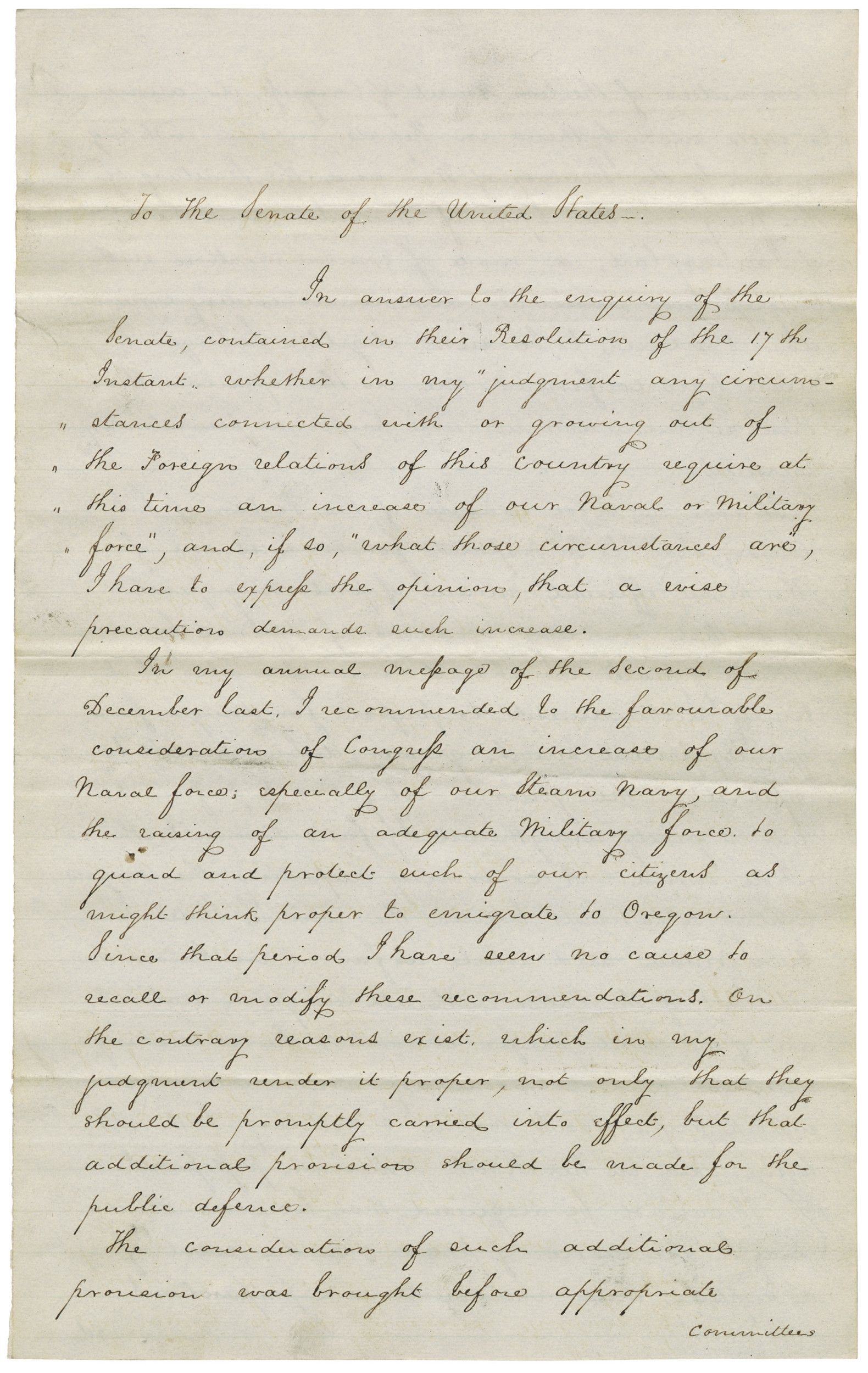
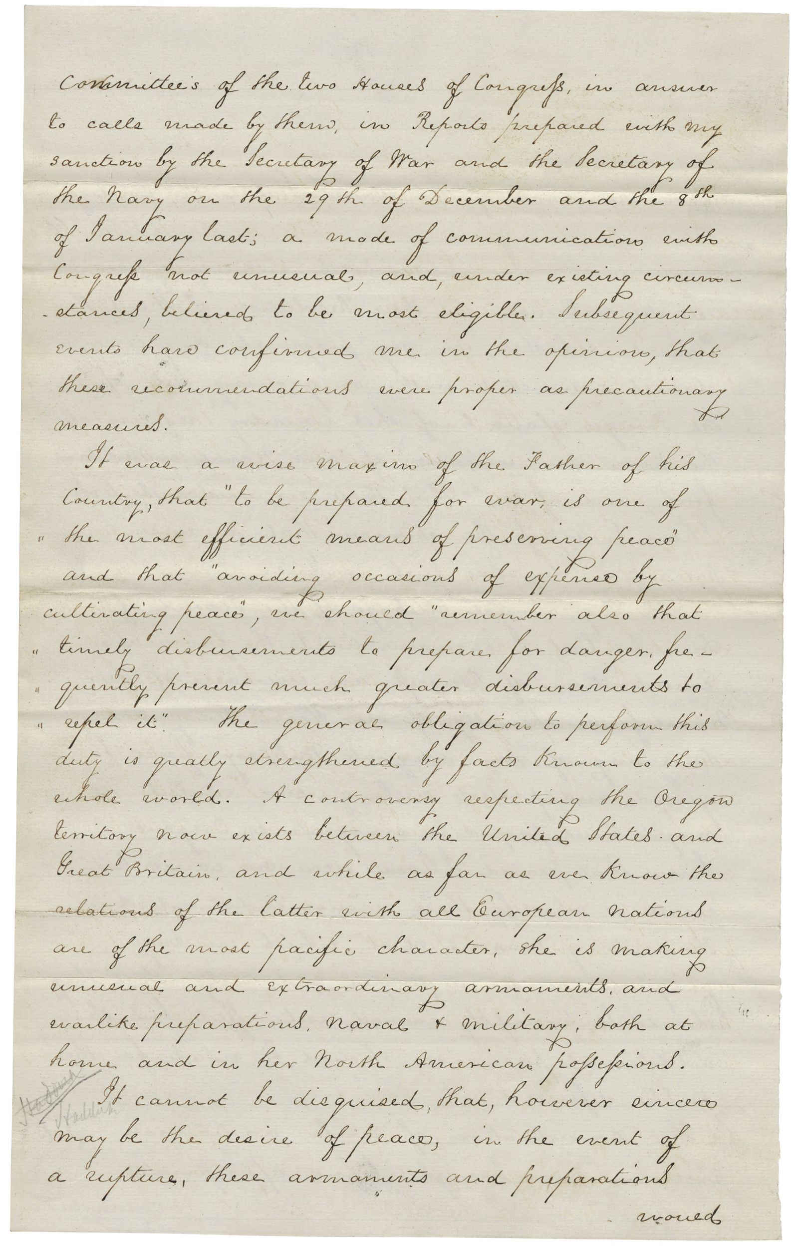
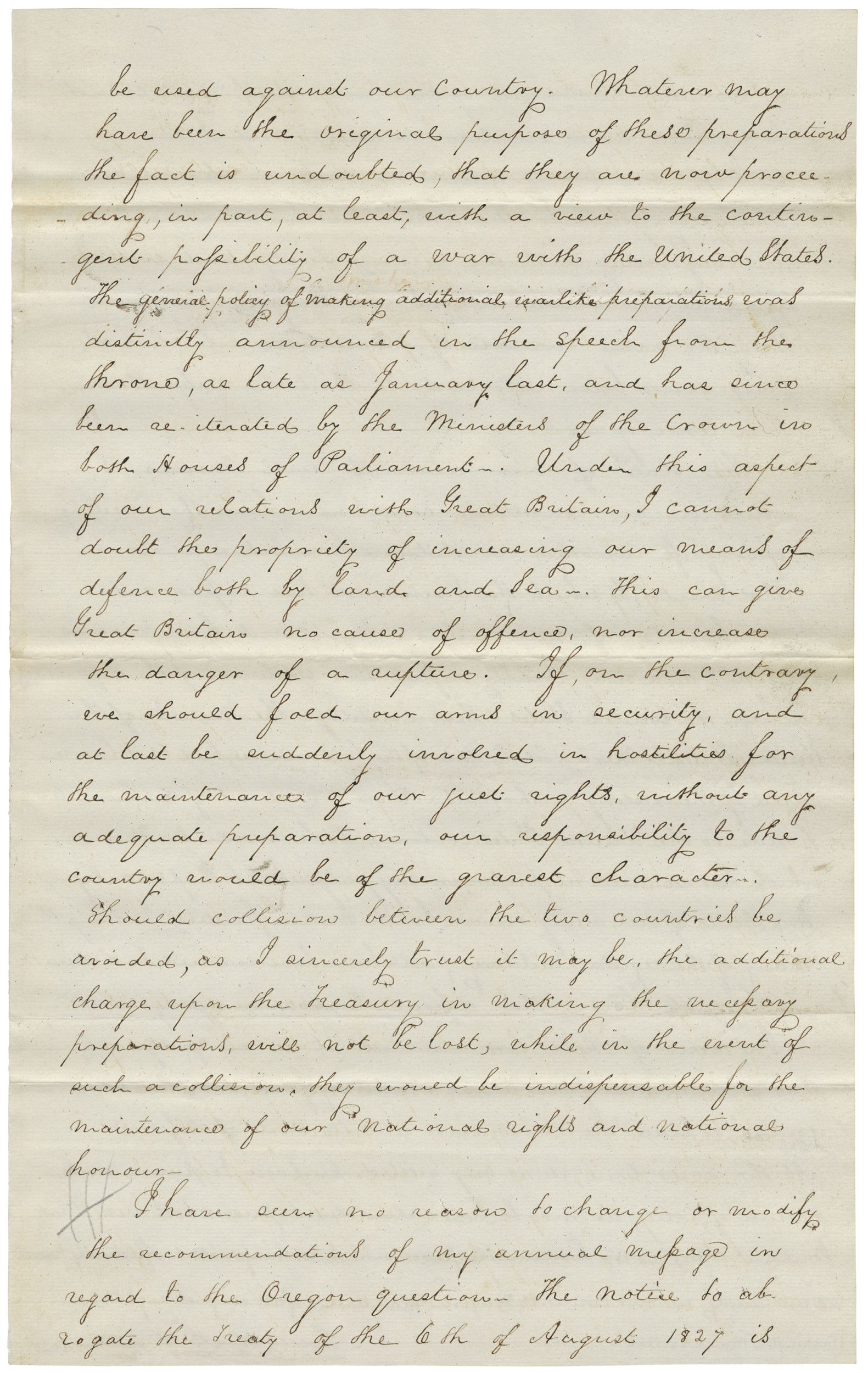
Message of President James K. Polk to the Senate Concerning the Defense of American Citizens in the Oregon Territory
3/24/1846
Additional details from our exhibits and publications
Message of President James K. Polk to the Senate Concerning the Defense of American Citizens in the Oregon Territory.
This primary source comes from the Records of the U.S. Senate.
National Archives Identifier: 595382
Full Citation: Message of President James K. Polk to the Senate Concerning the Defense of American Citizens in the Oregon Territory; 3/24/1846; Presidential Messages, 1789–1875; Records of the U.S. Senate, ; National Archives Building, Washington, DC. [Online Version, https://docsteach.org/documents/document/message-of-president-james-k-polk-to-the-senate-concerning-the-defense-of-american-citizens-in-the-oregon-territory, May 4, 2024]Message of President James K. Polk to the Senate Concerning the Defense of American Citizens in the Oregon Territory
Page 1
Message of President James K. Polk to the Senate Concerning the Defense of American Citizens in the Oregon Territory
Page 2
Message of President James K. Polk to the Senate Concerning the Defense of American Citizens in the Oregon Territory
Page 3
Message of President James K. Polk to the Senate Concerning the Defense of American Citizens in the Oregon Territory
Page 4

Message of President James K. Polk to the Senate Concerning the Defense of American Citizens in the Oregon Territory
Page 5

Document
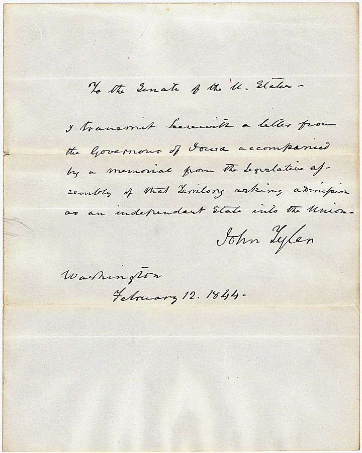
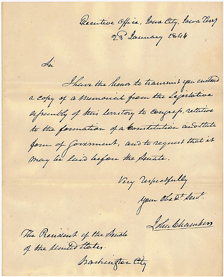
Message of President John Tyler transmitting to Congress a letter from John Chambers, Governor of Iowa, accompanied by a memorial from the legislative assembly of Iowa asking to be admitted as a state
2/12/1844
Transcript
To the Senate of the U. States -I transmit herewith a letter from the Governor of Iowa accompanied by the memorial from the Legislative assembly of that territory asking admission as an independent state into the Union.
John Tyler
Washington
February 12, 1844 -
Executive Office, Iowa City, Iowa Terry
23 January 1844
Sir
I have the honor to transmit your action a copy of the memorial from the Legislative assembly of this territory to congress, relative to the formation of a Constitution and State form of government, and to request that it may be laid before the Senate.
Very Respectfully
John Chambers
The President of the Senate of the United States.
Washington City
Memorial to Congress relative to the formation of a Constitution and State Government-
To the Honorable the Senate and House of Representatives of the United States in Congress Assembled,
Your memorialists the Council and Houses of Representatives of the Territory of Iowa: respectfully ask the Congress of the United States. To pass an act authorizing the people of the said Territory to hold a convention for the purpose of forming a Constitution and State Government at such time, place and under such regulations as the Legislative Assembly of the said Territory may prescribe and also making an appropriation of Twenty thousand dollars for defraying the expenses of said Convention and also defining the boundaries of the new State_
Your memorialists would respectfully suggest the following as the most natural and suitable boundaries for one State, To wit.
Beginning at the middle of the main channel of the Mississippi River at a point east of the middle of the main channel of the Des Moines River where it empties into the Mississippi river thence up the Mississippi river following the middle of the main channel of the same to the forty fifth degree of North latitude, thence on the parallel of said forty fifth degree of
North latitude to the middle of the main channel of the Missouri river, thence down the Missouri river following the middle of the main channel thereof to a point west of the line that may be established by Congress under the act “approved June 18th 1838_ Entitled an act to authorize the President of the United States to cause the southern boundary line of the Territory of Iowa to be ascertained and marked,” thence east with said line to the middle of the main channel in the Des Moines river, thence downward along the middle of the main channel of the Des Moines river to the place of beginning -
Resolved, That his excellency the Governor, be requested to forward copies of the foregoing memorial to the President of the Senate, the Speaker of the House of Representatives, and to our Delegate in Congress _
James P Carleton
Speaker of the House of Rep
Approved January 19th 1844 Thomas Cox
John Chambers President of Council
Territory of Iowa
Secretary’s Office
I, Samuel J. Burr, Secretary of the said Territory do certify, that the foregoing is a true copy from the original memorial filed in my office.
In testimony whereof I have hereunto affixed the seal of the said Territory at Iowa City, this 26th day of January in the 1844.
- J. Burr Secretary of Iowa Territory
This primary source comes from the Records of the U.S. Senate.
National Archives Identifier: 306497
Full Citation: Message of President John Tyler transmitting to Congress a letter from John Chambers, Governor of Iowa, accompanied by a memorial from the legislative assembly of Iowa asking to be admitted as a state; 2/12/1844; Records of the U.S. Senate, . [Online Version, https://docsteach.org/documents/document/message-of-president-john-tyler-transmitting-to-congress-a-letter-from-john-chambers-governor-of-iowa-accompanied-by-a-memorial-from-the-legislative-assembly-of-iowa-asking-to-be-admitted-as-a-state-i, May 4, 2024]Message of President John Tyler transmitting to Congress a letter from John Chambers, Governor of Iowa, accompanied by a memorial from the legislative assembly of Iowa asking to be admitted as a state
Page 1

Message of President John Tyler transmitting to Congress a letter from John Chambers, Governor of Iowa, accompanied by a memorial from the legislative assembly of Iowa asking to be admitted as a state
Page 2
Message of President John Tyler transmitting to Congress a letter from John Chambers, Governor of Iowa, accompanied by a memorial from the legislative assembly of Iowa asking to be admitted as a state
Page 3

Message of President John Tyler transmitting to Congress a letter from John Chambers, Governor of Iowa, accompanied by a memorial from the legislative assembly of Iowa asking to be admitted as a state
Page 4

Message of President John Tyler transmitting to Congress a letter from John Chambers, Governor of Iowa, accompanied by a memorial from the legislative assembly of Iowa asking to be admitted as a state
Page 5

Document
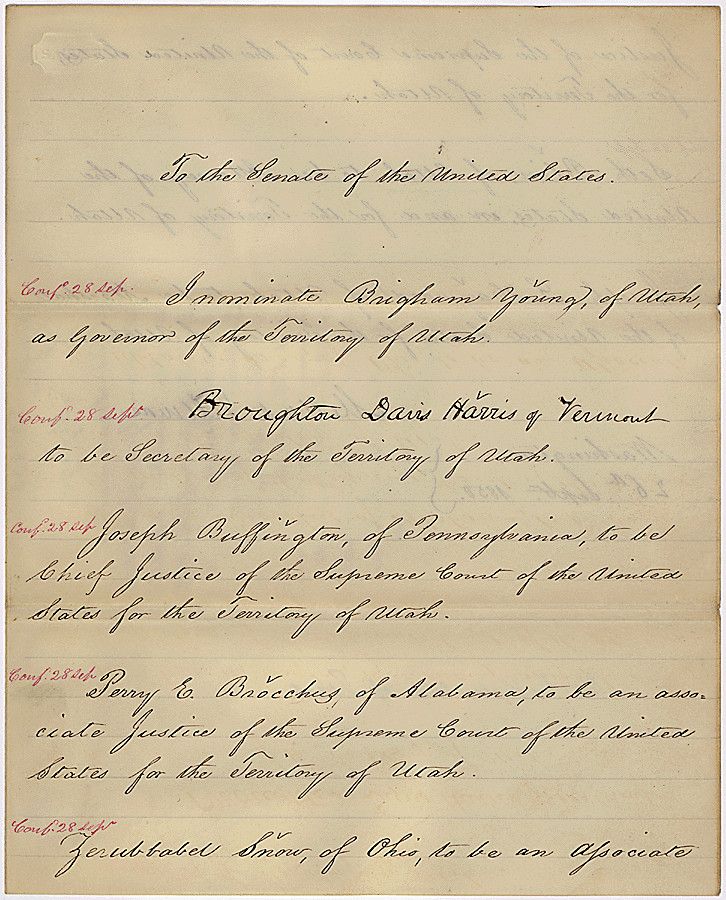
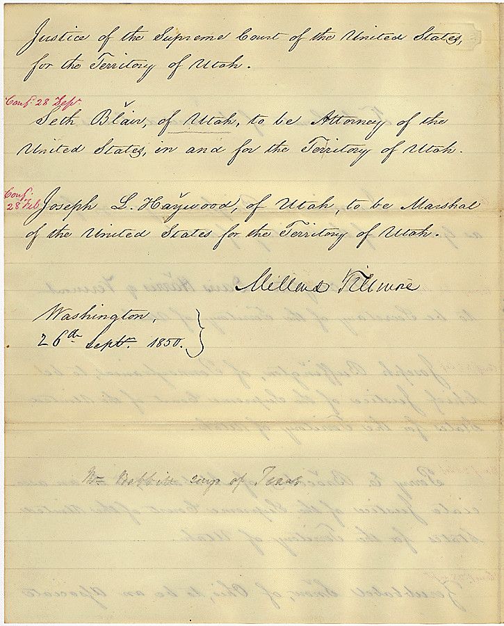
Message of President Millard Fillmore nominating territorial officers of Utah, including Brigham Young to be Governor
9/6/1850
President Millard Fillmore sent this message to the Senate nominating territorial officers of Utah, including Brigham Young to be Governor.
Transcript
To the Senate of the United States.Conf 28 Sept. I nominate Brigham Young, of Utah, as Governor of the Territory of Utah.
Conf 28 Sept. Broughton Davis Harris of Vermont to be Secretary of the Territory of Utah.
Conf 28 Sept. Joseph Buffington of Pennsylvania, to be Chief Justice of the Supreme Court of the United States for the Territory of Utah.
Conf 28 Sept Terry E Brocchus, of Alabama, to be associate Justice of the Supreme Court of the United States for the Territory of Utah
Conf 28 Sept. Ferubbabel Snow of Ohio, to be Associate
Justice of the Supreme Court of the United States for the Territory of Utah.
Conf 28 Sept, Seth Blair, of Utah to be Attorney of the United States, in and for the Territory of Utah
Conf 28 Sept Joseph L Haywood, of Utah, to be Marshall of the United States for the Territory of Utah.
Millard Fillmore
Washington,
26 Sept. 1850.
This primary source comes from the Records of the U.S. Senate.
National Archives Identifier: 306432
Full Citation: Message of President Millard Fillmore nominating territorial officers of Utah, including Brigham Young to be Governor; 9/6/1850; Executive Nominations for the First Session of the 31st Congress; Executive Nominations, 1789 - 2002; Records of the U.S. Senate, ; National Archives Building, Washington, DC. [Online Version, https://docsteach.org/documents/document/fillmore-nominations, May 4, 2024]Message of President Millard Fillmore nominating territorial officers of Utah, including Brigham Young to be Governor
Page 1
Message of President Millard Fillmore nominating territorial officers of Utah, including Brigham Young to be Governor
Page 2
Document
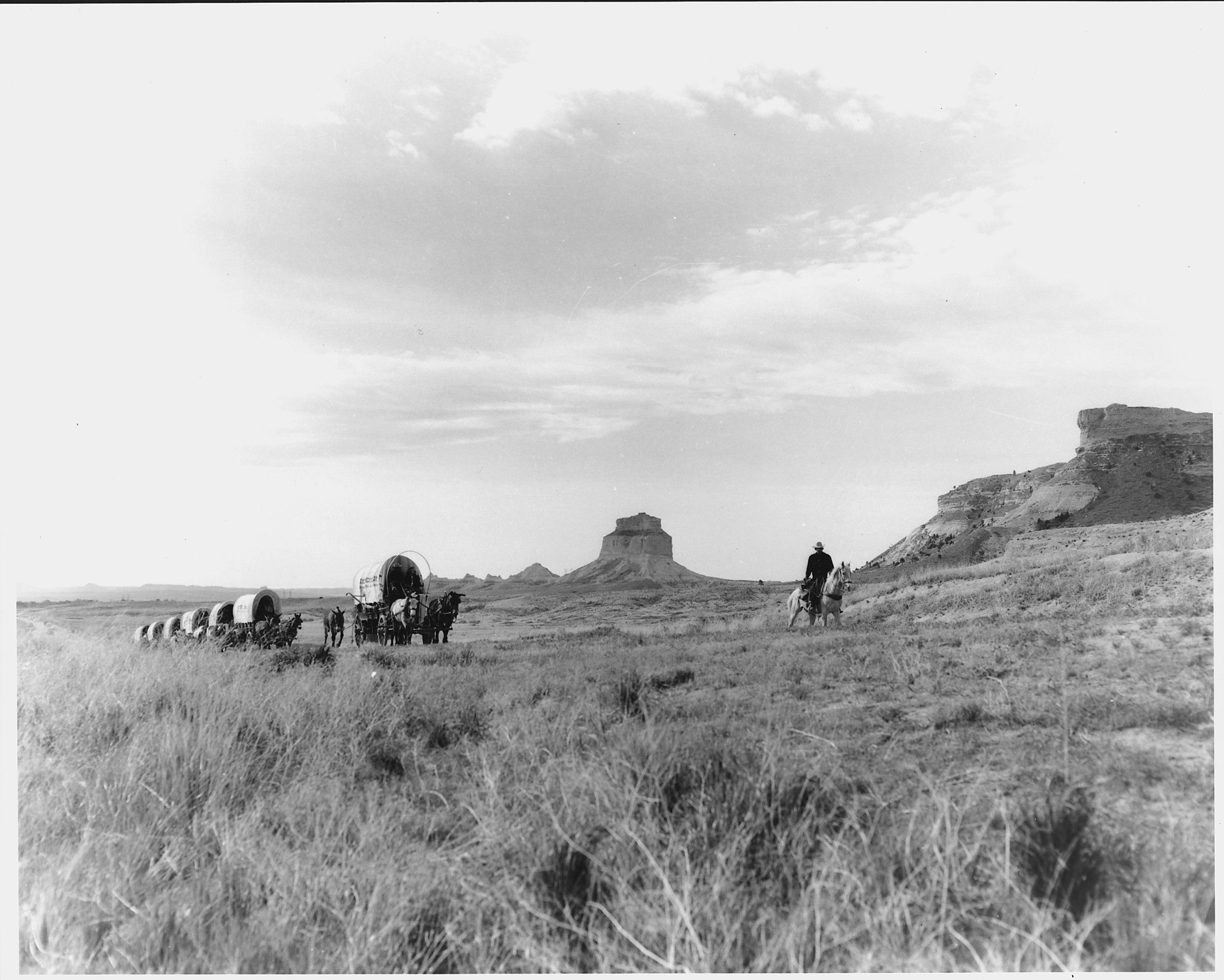
Oregon Trail Reenactment
Those who attempted to traverse the Oregon Trail did so knowing it would be a largely difficult and dangerous journey. This photograph shows a mounted man leading a wagon train past rock formations. This 20th-century image comes from a series of National Park Service photographs depicting the history of the "Old West."
This primary source comes from the Records of the National Park Service.
National Archives Identifier: 286052
Full Citation: Oregon Trail Reenactment; Records of the National Park Service, . [Online Version, https://docsteach.org/documents/document/oregon-trail-reenactment, May 4, 2024]Oregon Trail Reenactment
Page 1

Document
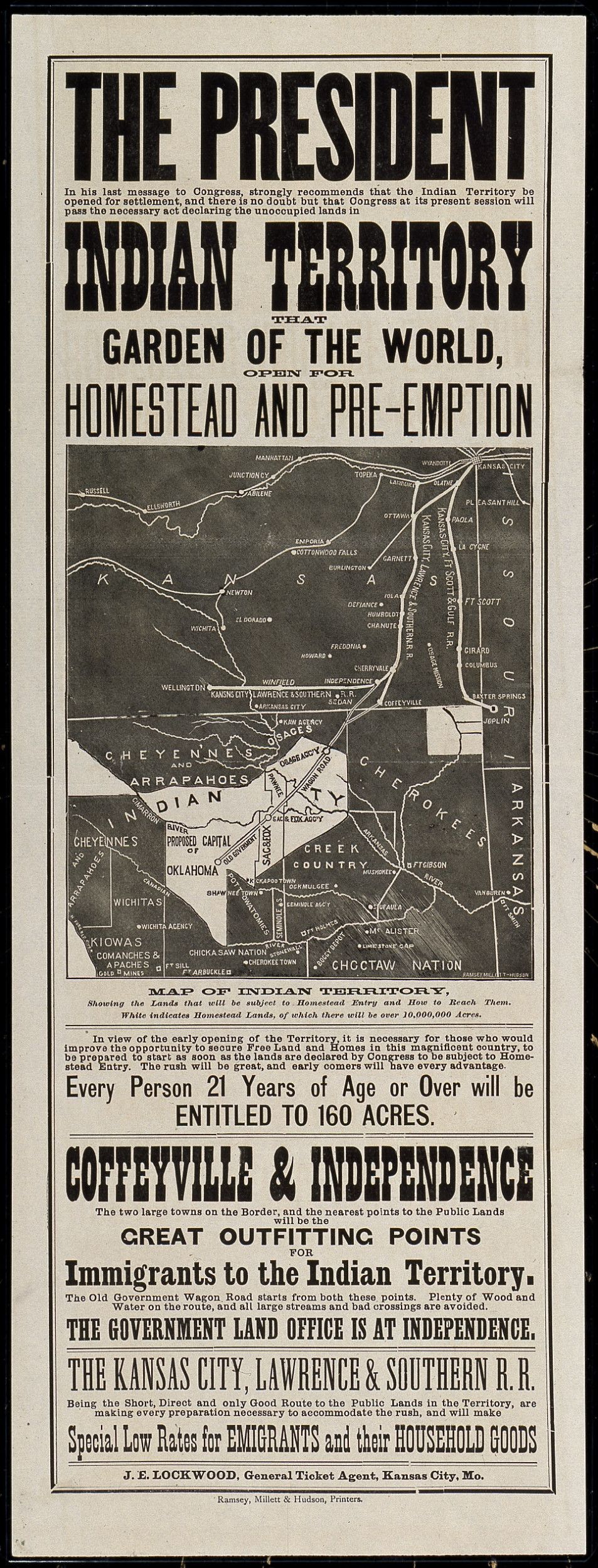
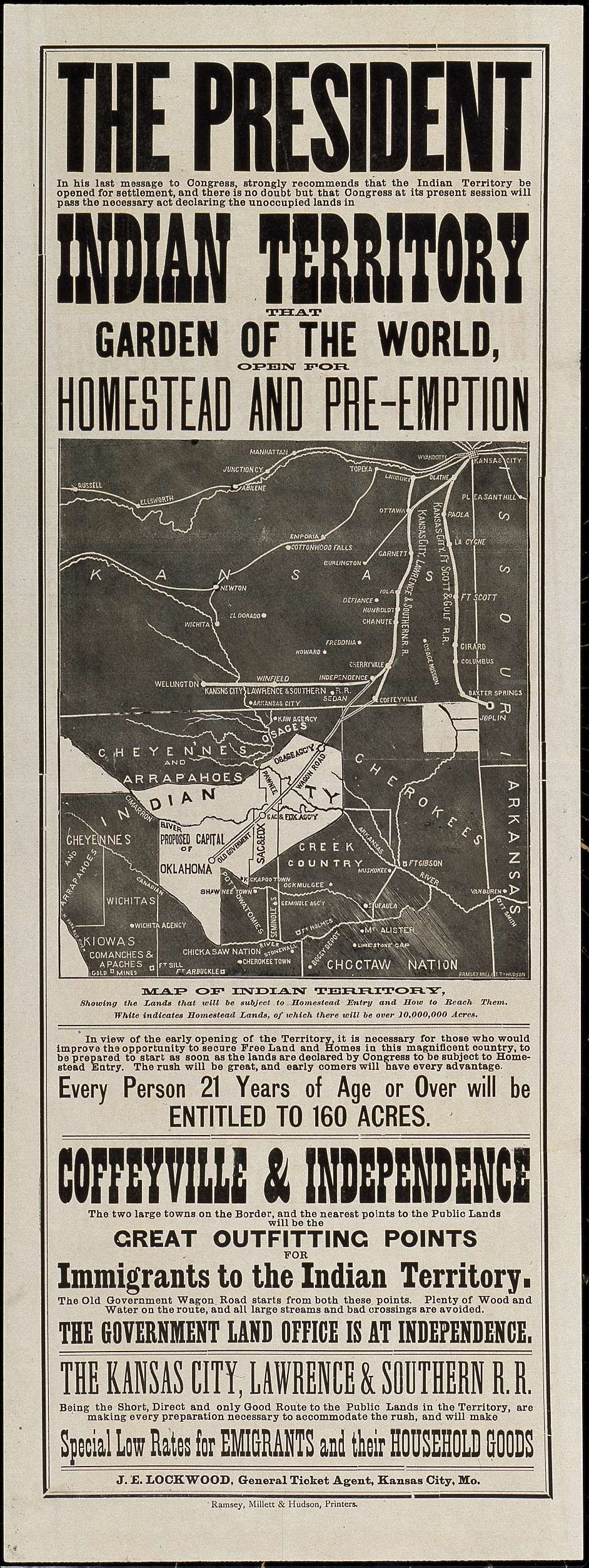
Poster Advertising 'Indian Territory That Garden of the World, Open for Homestead and Pre-Emption' in Current Day Oklahoma
ca. 1889
The Homestead Act passed on May 20, 1862. It greatly accelerated settlement of the western United States, providing 160 acres of free land to qualified citizens, very often at the expense of displaced American Indians.
Beginning in the 1800s, the Federal government resettled several American Indian tribes into Indian Territory. But then in the late 1800s, Congress adopted a policy of giving individual farms to American Indians on reservations and opening the remaining Indian lands to settlers. The most famous opening was the "land rush" in Oklahoma Territory.
This poster advertises railroad travel for "immigrants to the Indian Territory." It presumes that land in current-day Oklahoma would soon be open to settlement. It says that, in his last message to Congress (President Grover Cleveland's annual message to Congress on December 3, 1888), the President strongly recommended "that the Indian Territory be opened for settlement, and there is no doubt but that Congress...will pass the necessary act declaring the unoccupied lands in Indian Territory...open for homestead and pre-emption." The Indian Appropriations Act of 1889 officially opened "unassigned lands" in Oklahoma Territory to white settlers under the guidelines of the Homestead Act.
The advertisement includes a "map of Indian Territory showing the Lands that will be subject to Homestead Entry and How to Reach Them...of which there will be over 10,000,000 Acres" and says "The rush will be great, and early comers will have every advantage."
This primary source comes from the Records of U.S. Army Continental Commands.
National Archives Identifier: 4662607
Full Citation: Poster Advertising 'Indian Territory That Garden of the World, Open for Homestead and Pre-Emption' in Current Day Oklahoma ; ca. 1889; Letters Received, 11/1863 - 12/1904; Records of U.S. Army Continental Commands, ; National Archives Building, Washington, DC. [Online Version, https://docsteach.org/documents/document/indian-territory-poster, May 4, 2024]Poster Advertising 'Indian Territory That Garden of the World, Open for Homestead and Pre-Emption' in Current Day Oklahoma
Page 2
Document
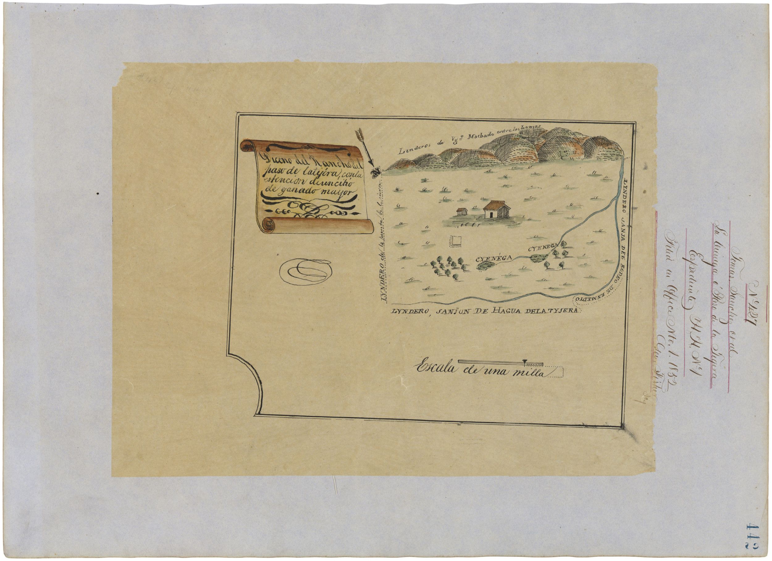
Sketch Map (Diseno) of California Land Claim
ca. 1852
Additional details from our exhibits and publications
The Mexican Cession of 1848 transferred 529,017 square miles of territory to the United States—along with jurisdiction over a legal battle for a league of land left by Vicente Sanchez, who died in 1846. This hand-drawn map, or diseno, of his ranch, along with a claim appealing the division of the land, was filed in 1852 with the California Land Commission, which eventually confirmed (at right) the division of the land between Sanchez’s widow and a descendant.
This primary source comes from the Records of the Bureau of Land Management.
National Archives Identifier: 595794
Full Citation: Sketch Map (Diseno) of California Land Claim; ca. 1852; California Land Claim Sketch Maps, ca. 1852 - ca. 1856; Records of the Bureau of Land Management, ; National Archives at College Park, College Park, MD. [Online Version, https://docsteach.org/documents/document/sketch-map-diseno-of-california-land-claim, May 4, 2024]Sketch Map (Diseno) of California Land Claim
Page 1
